There are two coordinate systems that astronomers use to specify and locate objects in the sky, the Equatorial Coordinate System and the Horizontal Coordinate System. If an equatorial mount is used then the Equatorial Coordinate system is used. If an altitude-azimuth (alt-az) mount is used then the Horizontal Coordinate System is used. Both these systems are described by means of the imaginary Celestial Sphere.
The Celestial Sphere Equatorial Coordinate System
-
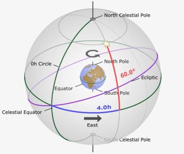
Celestial Sphere Equatorial Coordinate System (Permission of Astronomy Education At The University of Nebraska-Lincoln)
The Celestial Sphere is an imaginary concept used by astronomers to help describe the movement of the night sky from the perspective of that of the observer on Earth and is not a factual representation of actual celestial motion.
Imagine a sphere of infinite radius surrounding the earth. Think of the sphere as a planetarium sky dome and the Earth is in the center. All objects in the observers sky can be thought to be projected onto the surface of this dome. From your perspective the Earth is motionless and the objects in the sky are moving across the sky from East to West. The Earth actually rotates about its poles from west to east but due to relative motion, the sky appears to rotate in the opposite direction. Think of the Earth’s Equator as projected directly above into the Celestial Sphere, this is called the Celestial Equator. The Celestial Equator divides the Celestial Sphere into two halves North and South as does the Equator divide the Earth into the North and South Hemispheres.
The Celestial Sphere is also tipped relative to the observer in the same way as is the Earth. This extension of the Earth’s rotational axis to the Celestial Sphere defines the North and South Celestial Poles. The NCP is in the constellation close to the direction of the star Polaris, also called the North Star. The SCP is in the modern constellation Octans, called the Octant and in the general direction of the faint southern pole star Sigma Octantis (Polaris Australis).
The Sun appears to travel from east to west in a path across the sky called the Ecliptic. Where the Ecliptic crosses the Celestial Equator at the Vernal Equinox, in the Constellation Pisces, the point is called the First Point of Aries. The First Point of Aries is considered to be the Celestial Prime Meridian from which right ascensions are calculated. It is at this point that 0 hour of Right Ascension is defined. Right Ascension increases from west to east, from 0 hours to 24 hours. The reason for this is because this is the actual direction the Earth rotates and it takes 24 hours for one complete rotation. The Celestial Equator is defined as 0 degrees declination. The NCP and SCP are therefore +90 degrees declination and -90 degrees declination, respectively. Above your head is your zenith, while directly below you is your nadir, both being points on the Celestial Sphere.
In the Equatorial Coordinate System the positional coordinates of a celestial object is specific and constant. Two observers of the same star at the same time but from different observational locations on the Earth would be able to find the object using the same coordinates of the object. The coordinates are constant because the positional grid of the imagined Celestial Sphere is a sky based system which moves with the sky by definition and that the position of an object is based on defined positions in the Celestial Sphere.
The RA of an object in the sky is measured eastward along the Celestial Equator from the Vernal Equinox, (one of two places where the Celestial Equator crosses the Elliptic) from 0 to 24 hours and can be measured in hours, minutes and seconds. Alternatively, the Hour Angle (HA or LHA) measures the angular distance of a celestial object westward from the observer’s local meridian instead, along the Celestial Equator. The Dec of an object in the sky is measured from the Celestial Equator northward as + 0 to +90 degrees and southward as – 0 to -90 degrees. The positional location in the sky of an object is therefore specified by the RA (Right Ascension) and Dec (Declination) or the LHA and Dec coordinates.
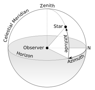
Horizon Coordinate System
-
The Horizon Coordinate System (Thanks to Wikipedia)
